Give project managers and site engineers one platform — web + Android — to record daily progress, track resources, manage issues, and stay ahead of schedule. Works offline. Syncs automatically.
Most construction teams struggle with fragmented tools, lost data, and poor visibility. Sound familiar?
Critical site updates buried in endless group chats. Photos lost in message history.
Multiple versions of reports floating around. No single source of truth.
No GPS data on where work was done. Chainage errors causing rework.
Site has no network. Can't record daily progress. Work stops.
Whether you manage a single site or a portfolio of projects, MapMyProject adapts to how your team works.
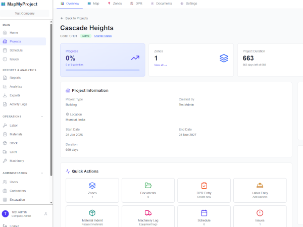
One dashboard to track all sites. Real-time DPR approvals, resource usage, and schedule deviation — without chasing updates from engineers.
Record daily progress from your phone — even offline. GPS-tagged photos, activity quantities, and labour attendance in one app.
Standardise reporting across all projects — buildings, roads, railways, pipelines. One format, one platform, one version of the truth.
Everything you need to monitor construction projects effectively — in one integrated system.
Comprehensive dashboard for project managers and admins. Create projects, assign teams, approve DPRs, generate reports.
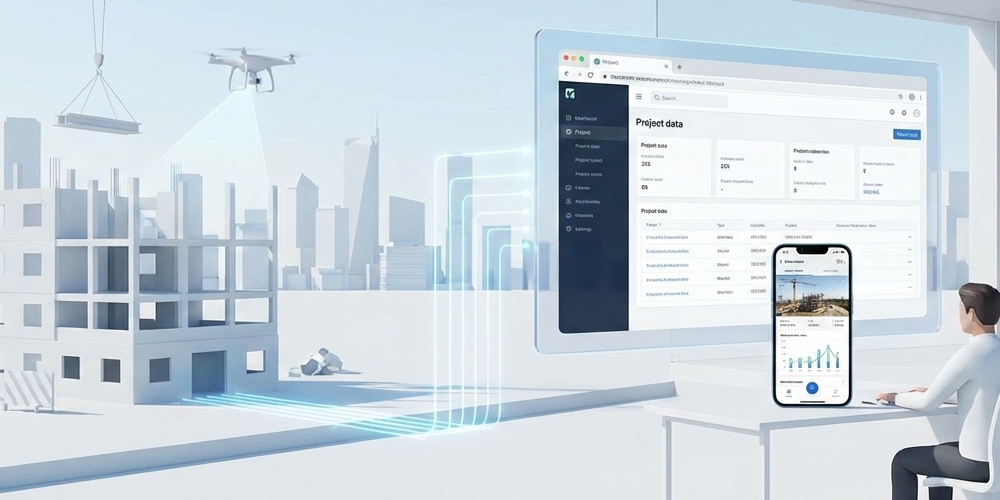
Field engineers capture progress on-site with offline support. GPS-tagged photos, automatic sync when online.
Secure, scalable infrastructure. Access from anywhere. Real-time updates across all devices.
Everything you need to monitor, track, and report on construction projects effectively.
Define your construction site spatially — draw polygon areas, polyline routes, and point locations directly on satellite imagery, or import from existing GIS files. Organise zones by type, level, floor, and drawing sheets.
Go beyond basic mapping. Toggle smart layers — activity heatmaps, colour-coded progress, photo markers, issue pins, and a timeline slider — all overlaid on satellite imagery in real time.
In addition to area-based projects, purpose-built features for roads, highways, railways, and pipelines. Define a master centreline, create zones along chainage, record DPR progress by chainage range, and watch the work front advance on the map.
Create project schedules with activities and timelines or import from a CSV file. Track actual vs planned progress and identify delays before they escalate.
Structured daily reporting with photo documentation. Field teams record work done, quantities, and equipment used — with shift-wise tracking and manager approval workflows.
Costs are calculated automatically when a DPR is submitted — pulling from that day's labour attendance, machinery hours, and material consumption. See planned vs actual vs variance in one dashboard.
Daily attendance tracking for labour. Record machinery usage, fuel consumption, and running hours for accurate cost accounting and productivity analysis.
Track material indents, stock levels, and consumption. Maintain accurate records of material movement from procurement to site usage, including goods receipt verification.
Track site issues from identification to resolution. Assign to team members, set priorities, attach photos, and monitor status — ensuring nothing falls through the cracks.
Centralized repository for all project documents. Upload drawings, specifications, approvals, and test reports — with version control, categorisation, and easy search.
Comprehensive reports and dashboards for every project type. Track progress against schedule, identify bottlenecks, and generate client-ready reports instantly in PDF, Excel, or CSV.
Granular access control with role-based permissions. Company Admin, Manager, and field roles with appropriate access levels, project-specific assignments, and a full audit trail.
Want to understand what construction project tracking software can do for your team?
Read the Complete Construction Tracking Software Guide →From highways to high-rises, MapMyProject adapts to your industry needs.

Chainage-based tracking, linear zone management, layer-wise progress monitoring.

Floor-wise progress, multiple blocks, activity scheduling, quality checklists.

Component-based tracking (piers, girders, deck), critical path monitoring.
Station-wise progress, track work monitoring, utility relocations, safety compliance.

Pipeline tracking, pumping station progress, treatment plant construction.

Factory construction, warehouses, equipment installation, commissioning tracking.
From trial signup to full deployment in under 1 hour.
Fill out our trial request form with your company details and project requirements. We'll set up your account within 24 hours.
Create your first project, add team members, configure settings. Our support team guides you through the process.
Field teams install the mobile app and start recording progress. See real-time updates on the web dashboard immediately.
✓ 1-month free trial ✓ No credit card required ✓ Setup support included
Watch our 2-minute overview to see how construction teams use MapMyProject daily.
Got questions? We have answers.
Currently, we have an Android app available on the Google Play Store. iOS version is in development and will be released soon.
Request a trial account through our form. We'll set up your account within 24 hours with full feature access. The trial lasts 1 month. No credit card required upfront.
MapMyProject supports both linear projects (roads, highways, pipelines) with chainage tracking, and area projects (buildings, complexes, industrial facilities). Fully adaptable to any construction type.
All data is encrypted in transit and at rest. We use enterprise-grade cloud infrastructure with daily backups. Company data is completely isolated with role-based access control.
Still have questions?
Contact Our Team →Give your team one platform for daily progress, resources, issues, and reporting. Start your free trial — setup in under 1 hour, no credit card required.
✓ Setup in under 1 hour ✓ Free training included ✓ No long-term contracts